GLC_FCS30D - 全球 30 米土地覆被變化數據集(1985-2022 年)
注
本數據集是正在提交的論文的一部分,因此沒有引用和 DOI 信息。請在使用本數據集時注意這一點。
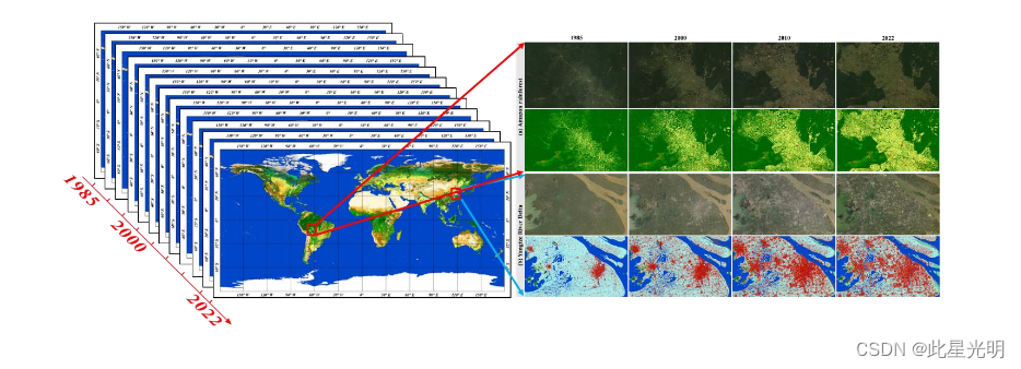
GLC_FCS30D 數據集是全球土地覆被監測領域的一項開創性進展,它以 30 米的分辨率全面揭示了從 1985 年到 2022 年期間的土地覆被動態。GLC_FCS30D 采用連續變化探測方法開發,利用了谷歌地球引擎平臺中大量的陸地衛星圖像檔案,包括 35 個土地覆被子類別和 26 個時間步長,2000 年之前每五年更新一次,之后每年更新一次。通過嚴格的完善過程,包括時空分類和時間一致性優化,該數據集實現了高置信度的準確性,經過 84,000 多個全球樣本的驗證,總體準確率達到 80.88%。值得注意的是,GLC_FCS30D 闡明了重要趨勢,揭示了森林和耕地變化是過去 37 年全球土地覆被變化的主要驅動因素,森林凈損失約 250 萬平方公里,耕地面積凈增加約 130 萬平方公里。GLC_FCS30D 具有多樣化的分類系統、高空間分辨率和廣泛的時間覆蓋范圍,是氣候變化研究和可持續發展分析的寶貴資源。前言 – 人工智能教程
?
GLC_FCS30D 是首個采用連續變化探測技術的 30 米分辨率全球精細土地覆被動態產品。它采用了一套包含 35 個土地覆被類別的精細分類系統,時間跨度為 1985 年至 2022 年。2000 年之前,更新周期為每 5 年一次,2000 年之后,更新周期為每年一次。具體而言,該系統結合了連續變化檢測方法、局部自適應更新模型和來自密集時間序列大地遙感衛星圖像的時空優化算法,經過驗證,基本分類系統(10 個主要土地覆被類型)的總體精度為 80.88%(±0.27%),LCCS 一級驗證系統(17 個 LCCS 土地覆被類型)的總體精度為 73.24%(±0.30%)。
數據鏈接
GLC_FCS30D: the first global 30-m land-cover dynamic monitoring product with fine classification system from 1985 to 2022
土地分類類型
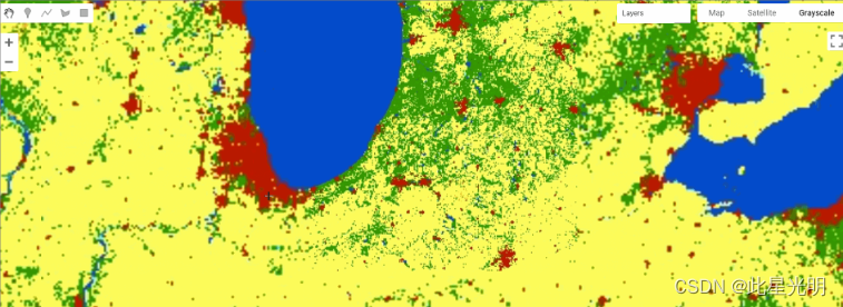
展開以顯示土地覆被等級、RGB 值和十六進制代碼
| LC Id | Classification System | RGB value | Color |
|---|---|---|---|
| 10 | Rainfed cropland | (255,255,100) | |
| 11 | Herbaceous cover cropland | (255,255,100) | |
| 12 | Tree or shrub cover (Orchard) cropland | (255,255,0) | |
| 20 | Irrigated cropland | (170,240,240) | |
| 51 | Open evergreen broadleaved forest | (76,115,0) | |
| 52 | Closed evergreen broadleaved forest | (0,100,0) | |
| 61 | Open deciduous broadleaved forest (0.15<fc<0.4) | (170,200,0) | |
| 62 | Closed deciduous broadleaved forest (fc>0.4) | (0,160,0) | |
| 71 | Open evergreen needle-leaved forest (0.15< fc <0.4) | (0,80,0) | |
| 72 | Closed evergreen needle-leaved forest (fc >0.4) | (0,60,0) | |
| 81 | Open deciduous needle-leaved forest (0.15< fc <0.4) | (40,100,0) | |
| 82 | Closed deciduous needle-leaved forest (fc >0.4) | (40,80,0) | |
| 91 | Open mixed leaf forest (broadleaved and needle-leaved) | (160,180,50) | |
| 92 | Closed mixed leaf forest (broadleaved and needle-leaved) | (120,130,0) | |
| 120 | Shrubland | (150,100,0) | |
| 121 | Evergreen shrubland | (150,75,0) | |
| 122 | Deciduous shrubland | (150,100,0) | |
| 130 | Grassland | (255,180,50) | |
| 140 | Lichens and mosses | (255,220,210) | |
| 150 | Sparse vegetation (fc<0.15) | (255,235,175) | |
| 152 | Sparse shrubland (fc<0.15) | (255,210,120) | |
| 153 | Sparse herbaceous (fc<0.15) | (255,235,175) | |
| 181 | Swamp | (0,168,132) | |
| 182 | Marsh | (115,255,223) | |
| 183 | Flooded flat | (158,187,215) | |
| 184 | Saline | (130,130,130) | |
| 185 | Mangrove | (245,122,182) | |
| 186 | Salt marsh | (102,205,171) | |
| 187 | Tidal flat | (68,79,137) | |
| 190 | Impervious surfaces | (195,20,0) | |
| 200 | Bare areas | (255,245,215) | |
| 201 | Consolidated bare areas | (220,220,220) | |
| 202 | Unconsolidated bare areas | (255,245,215) | |
| 210 | Water body | (0,70,200) | |
| 220 | Permanent ice and snow | (255,255,255) | |
| 0, 250 | Filled value | (255,255,255) |
?數據集后處理
數據集由約 961 個圖層組成,年度圖層由約 23 年的圖像組成,每個波段代表從 2000 年開始的一年,5 年圖層從 1985 年開始,3 個波段代表 5 年的間隔,因此 1985-1990 年為 b1,1990-1995 年為 b2,1990-2000 年為 b3。
論文引用
Zhang, X., Zhao, T., Xu, H., Liu, W., Wang, J., Chen, X., and Liu, L.: GLC_FCS30D: The first global 30-m land-cover dynamic monitoring product with
a fine classification system from 1985 to 2022 using dense time-series Landsat imagery and continuous change-detection method, Earth Syst. Sci. Data
Discuss. [preprint], https://doi.org/10.5194/essd-2023-320, in review, 2023.
數據引用
Liangyun Liu, Xiao Zhang, & Tingting Zhao. (2023). GLC_FCS30D: the first global 30-m land-cover dynamic monitoring product with fine classification
system from 1985 to 2022 [Data set]. Zenodo. https://doi.org/10.5281/zenodo.8239305
數據集代碼
var annual = ee.ImageCollection("projects/sat-io/open-datasets/GLC-FCS30D/annual");
var five_year = ee.ImageCollection("projects/sat-io/open-datasets/GLC-FCS30D/five-years-map");
代碼鏈接
https://code.earthengine.google.com/?scriptPath=users/sat-io/awesome-gee-catalog-examples:global-landuse-landcover/GLC-FCS30D
License?
This work is licensed under and freely available to the public under Creative Commons Attribution 4.0 International license.
Created by: Zhang et al. 2023
Curated in GEE by : Samapriya Roy
Keywords: GLC_FCS30D, 1985-2022, Land-cover change, Landsat, change detection, Google Earth Engine
Last updated in GEE: 2024-02-20
?

)


)

)
)